Written by Aaron Studwell, Ph.D., Energy Meteorologist & Analyst, for IIR News Intelligence
Summary
A potentially historic El Niño will reshape North American temperature, precipitation and energy-demand patterns through fall 2026 and winter 2026-27.Strong Event Anticipated
North America is heading into fall with one unusually strong climate signal and one important complication. El Niño is rapidly strengthening, and NOAA's Climate Prediction Center (CPC) places the probability of a very strong event above 90% through fall into early 2027. The CPC also assigns a 69% chance that October-December reaches a historic threshold exceeding previous El Niño events since 1950.According to Industrial Info Resources data, this forecasted strong tropical Pacific forcing should increasingly influence North American weather as we race to the end of 2026. However, an unusual negative Pacific Decadal Oscillation (PDO) may modify the textbook El Niño response. The combination of this forcing creates greater uncertainty over exactly where persistent ridges and troughs become established.
Tropical Atlantic Outlook
Despite entering the climatological peak of hurricane season, the Atlantic remains favored for well below normal activity. Colorado State University (CSU) forecasts nine named storms, four hurricanes and one major hurricane for 2026, with Accumulated Cyclone Energy (ACE) near 40-45% of normal. These values include the three named storms -- Arthur, Bertha, and Cristobal --that occurred earlier this season.The primary suppressing influence remains El Niño. Stronger upper-level winds associated with the tropical Pacific Ocean climate state yield strong vertical wind shear across the tropical Atlantic and Caribbean. This pattern makes tropical cyclone development more difficult despite above normal sea surface temperatures across the tropical Atlantic.
Landfall risk is correspondingly lower, but not zero. CSU estimates a 16% probability of at least one major hurricane affecting the continental U.S. coastline during the remainder of the season. The historical full-season average is 43%. The Gulf Coast risk is estimated at 9%, versus 27% historically.
Fall 2026 North American Outlook
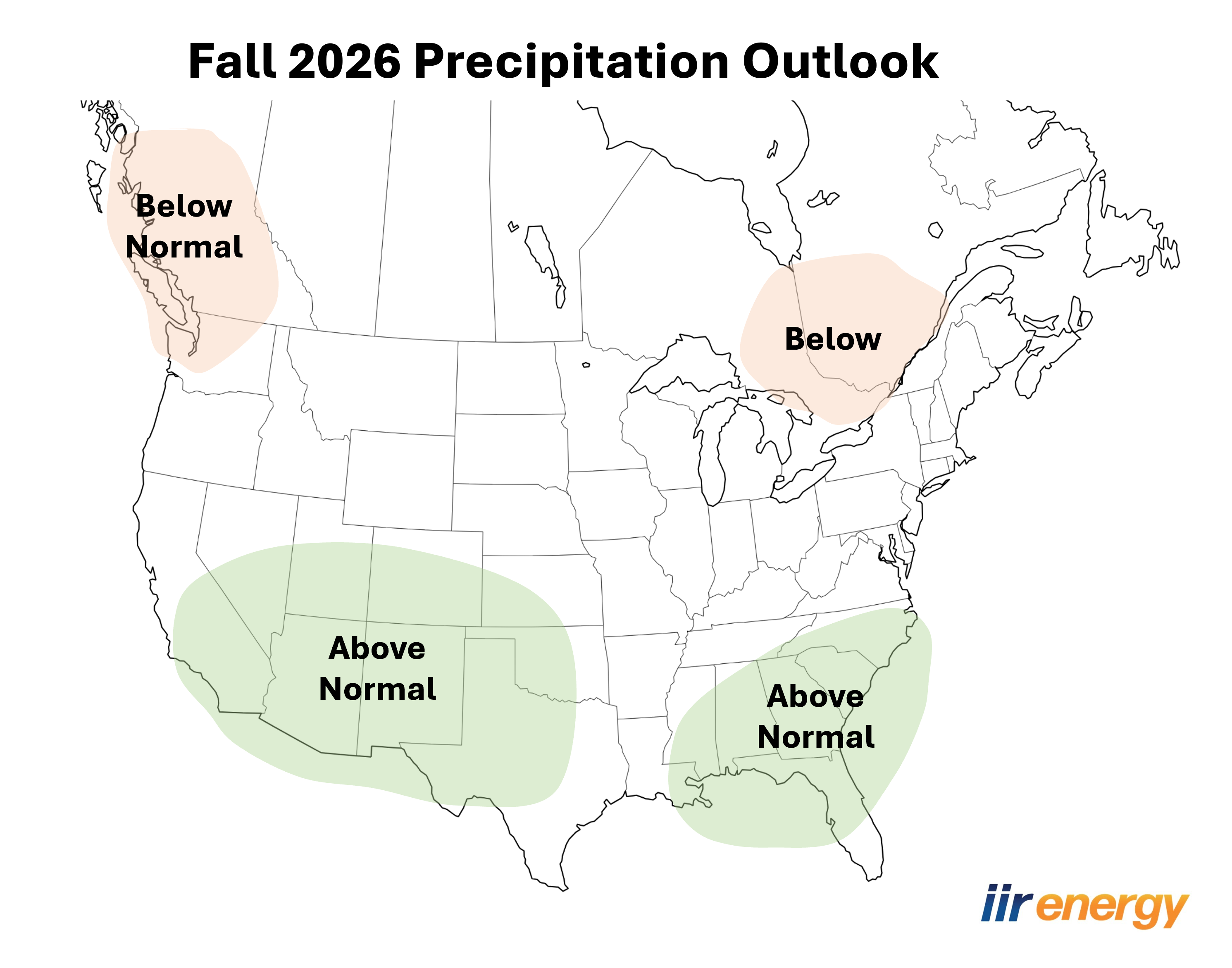
For the September-November time frame, El Niño forcing should increasingly strengthen the subtropical jet across the southern U.S. This pattern intensification will favor enhanced cloud cover and above-normal precipitation from Southern California toward Texas and into parts of the Southeast. These impacts also will carry over to northern Mexico, particularly Baja California and Sonora, along with northern portions of Chihuahua and Coahuila. The current forecast shows the enhanced rainfall across the southern U.S. as the most confident part of the IIR autumn outlook.Confidence in the North American temperature outlook is lower, with greater uncertainty surrounding the magnitude and placement of the expected differences from normal. The higher ambiguity in the outlook is the result of several competing influences potentially shaping the North American pattern.
Canada's autumn temperature outlook will be particularly sensitive to the interaction between the strengthening El Niño and the persistent negative PDO. The most likely outcome favors ridging across western and central Canada, supporting above-normal temperatures from British Columbia and the Prairies eastward toward Manitoba and portions of Ontario. This will also favor drier-than-normal conditions in British Columbia and Ontario. If the negative PDO exerts greater influence, the ridge and strongest warmth could shift farther east into Ontario, Quebec and Atlantic Canada, reducing the likelihood of sustained early-season cold across southern Canada. This development would also limit cold air movement into the Lower 48.

A stronger subtropical jet across the southern tier of the Lower 48 would yield below normal temperatures due to increased cloud cover and associated rainfall. Across Mexico, increased cloud cover and rainfall should limit daytime heating in the wetter northern areas, supporting temperatures closer to or locally below normal. Elsewhere in Mexico, temperatures are more likely to remain near to above seasonal averages, especially where precipitation is expected to be less persistent.
For energy markets, the pattern suggests a gradual shift from cooling demand toward precipitation and wind-related operational concerns. A wetter southern tier could periodically reduce solar generation. However, the above-normal precipitation will benefit water supplies and hydropower resources, when precipitation reaches western watersheds. Persistent northern warmth would delay the seasonal increase in heating-degree days (HDDs), particularly across portions of the Upper Midwest and southern Canada.
Winter 2026-27 North American Outlook
By the start of the upcoming winter season, the potentially record-breaking El Niño signal will be firmly established. A classic strong El Niño winter favors a continuing active southern storm track, increasing the likelihood of wetter conditions from California to the southeastern U.S. Additionally, strong upper-level ridging will generally favor milder conditions across northern portions of the continent.Winter should retain a broad El Niño influence across Canada, generally favoring warmer-than-normal temperatures across much of the country as the primary storm track remains displaced to the south. This would favor below-normal heating demand relative to climatology across major southern Canadian population centers, although episodic Arctic outbreaks remain possible.
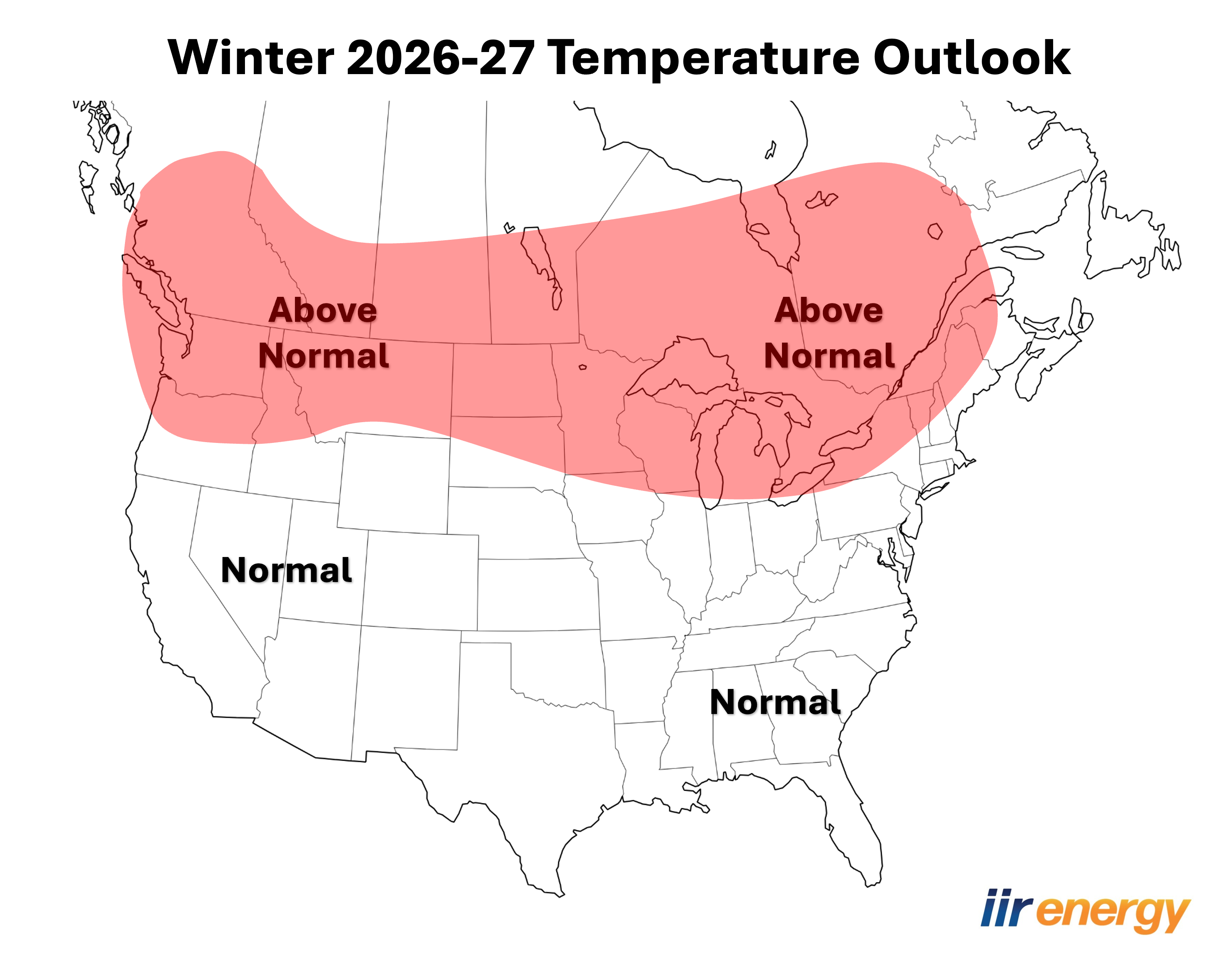
Precipitation confidence remains lower than temperature confidence, particularly because the negative PDO could alter the typical Pacific-North American pattern. Western Canada may experience periods of reduced Pacific storm activity if upper-level ridging persists. Eastern Canada could see greater precipitation variability depending on the position of the downstream storm track. The unprecedented combination of a very strong El Niño and negative PDO makes regional winter precipitation anomalies less certain.
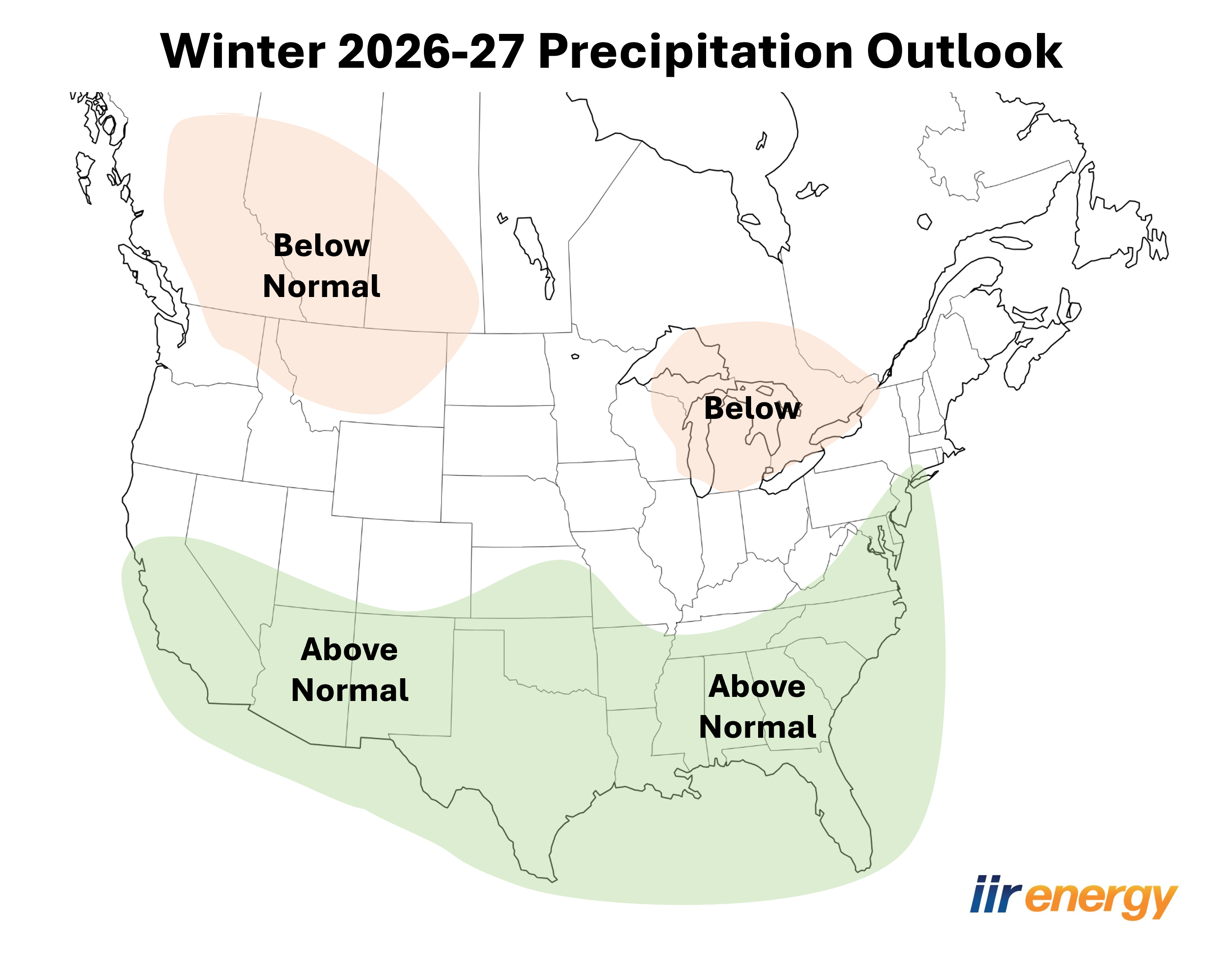
Across the United States, a strong El Niño should favor an active southern storm track, with above-normal precipitation extending from California and the Southwest through the Southern Plains, Gulf Coast and Southeast. Increased cloud cover and precipitation should favor near- to below-normal temperatures across portions of the southern tier. The northern U.S. is more likely to remain warmer than normal with persistent ridging and more southerly storm track.
This would generally suppress heating-degree-day demand across the northern tier, although periodic Arctic intrusions could still produce short-lived demand spikes. California and the Southwest could see increased precipitation and mountain snowfall, improving water supplies but periodically affecting transportation and energy operations.
Across northern Mexico, the El Niño precipitation signal is also expected to remain established during winter as the subtropical jet directs more Pacific moisture across the region. Temperatures could average near to somewhat below normal beneath the wetter and cloudier storm track, particularly across northern Mexico. Southern Mexico should generally remain warmer, with weaker and less predictable precipitation anomalies.
Meteorological Why's: ENSO and the Teleconnections
The intensifying El Niño is already strongly coupled to the atmosphere. Enhanced central and eastern Pacific convection and strong equatorial wind anomalies have resulted from this anticipated pattern evolution.
A complicating factor could be the North Pacific and how the atmospheric pattern evolves. Instead of transitioning to the positive PDO typically associated with strong El Niño events, the PDO remains negative. Additionally, forecast guidance suggests it may remain in a negative state into the upcoming winter. There are no comparable historical analogs in which strong El Niño forcing coexists with a substantially negative PDO, limiting confidence in this traditional seasonal forecast method.
That interaction matters for seasonally relevant teleconnections. Their shorter-term fluctuations will determine when seasonal tendencies translate into actual cold outbreaks, warm spells, and storm-track shifts. In other words, El Niño provides a strong background signal, but the Pacific and high-latitude teleconnections will determine how that signal manifests across the North American energy markets.
Key Takeaways
- A very strong El Niño is expected to dominate North American weather through fall and winter, with a 69% chance of reaching historic strength during October-December.
- Atlantic hurricane activity is forecast to remain well below normal, with CSU projecting nine named storms, four hurricanes and one major hurricane for 2026.
- Fall precipitation is expected to increase across the southern U.S. and northern Mexico as El Niño strengthens the subtropical jet.
- Fall temperatures should favor warmth across western and central Canada and portions of the northern U.S., while clouds and rainfall limit temperatures farther south.
- Winter should feature an active southern storm track, increasing precipitation from California through the Southern Plains, Gulf Coast and Southeast.
- Warmer conditions across Canada and the northern U.S. could suppress winter heating demand, although episodic Arctic outbreaks remain possible.
- The unusual combination of a potentially historic El Niño and negative PDO increases uncertainty and could alter traditional North American El Niño temperature and precipitation patterns.
About Industrial Info Resources
Industrial Info Resources (IIR) is the leading provider of industrial market intelligence. Since 1983, IIR has provided comprehensive research, news and analysis on the industrial process, manufacturing and energy related industries. IIR's Global Market Intelligence (GMI) helps companies identify and pursue trends across multiple markets with access to real, qualified and validated plant and project opportunities. Across the world, Industrial Info Resources is tracking over 250,000 current and future projects worth $30.2 trillion (USD).
/iirenergy/industry-news/article.jsp
false
Want More IIR News Intelligence?
Make us a Preferred Source on Google to see more of us when you search.
Add Us On GoogleAsk Us
Have a question for our staff?
Submit a question and one of our experts will be happy to assist you.

Explore Our EnergyLive Tools
EnergyLive Tools provide instant insight into new build, outages, maintenance, and capacity shifts across key energy sectors.
Explore Our Tools
Explore Our Enery Industry Reports
Gain the competitive edge with IIR Energy’s suite of energy market reports, designed for traders, analysts, and asset managers who rely on verified, real-time data.
View ReportsIndustry Intel
-
Latin America Data Center Outlook 2026: Power, Hubs & GrowthPodcast Episode / Oct 9, 2026
-
Food and Beverage CapEx Outlook 2026: Tariffs, AI, AfricaPodcast Episode / Oct 9, 2026
-
North America Refining 2026: New Pipelines to PADD 5Podcast Episode / Oct 2, 2026
-
Biomanufacturing Onshoring 2026: GLP-1, CDMO and ReshoringPodcast Episode / Oct 2, 2026
-
2026 US Data Center Outlook: Power, Land & CoolingPodcast Episode / Sep 18, 2026