Power
Slow Start in Tropical Atlantic Belies Above-Normal Forecast
This year is projected to be the latest start to the tropical Atlantic season since Tropical Storm Arthur was named on June 30, 2014
Released Friday, June 20, 2025

Written by Aaron Studwell for Industrial Info Resources (Sugar Land, Texas)--Since the year 2000, the average date of the tropical Atlantic's first named storm has been June 3. Excluding 2016, when Tropical Storm Alex was named on January 14, the daily average slides back to June 9. With the current forecast showing no tropical development expected over the next week, 2025 is projected to be the latest start to the tropical Atlantic season since Tropical Storm Arthur was named on June 30, 2014.
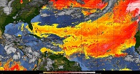
Globally, subtropical oceans, particularly parts of Pacific and Indian Oceans, have surged to record warmth. However, this extreme warmth may be contributing to fewer tropical storms by creating a more stable atmosphere. Additionally, a thick blanket of Saharan dust has extended across the central and eastern Atlantic, as far west as the eastern Caribbean. The Saharan Air Layer (SAL) also extends north of the Caribbean Sea, across the Bahamas and south Florida.
The dust and dry air associated with the SAL keeps sea surface temperatures near normal levels, while also yielding lower humidity levels. At this time, all but one of the tropical waves over the Atlantic have associated convection; that wave's convection is located at a convergence point with the monsoon trough and should dissipate as the wave continues west.
One factor influencing the Atlantic is a developing cooling pattern in the eastern tropical Atlantic, known as Atlantic Niña. Equatorial temperatures are averaging 1-2°C below normal between 5°E and 32°W. Recent research indicates that this emerging climate signal could suppress hurricane activity by altering atmospheric patterns and reducing favorable conditions for storm formation. Although the Atlantic Niña has yet to be officially classified, which requires three months of sustained cooling, early signs suggest it may be having an effect.
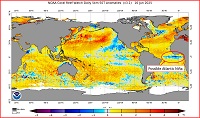
Part of the subtropical warming stems from the recent conclusion of an La Niña event. Climate change is also playing a role, with the 11 warmest Mays for subtropical ocean temperatures all occurring since 2015. While warmer oceans globally can sometimes fuel more intense hurricanes, long-term research suggests that the number of tropical storms may actually decline; however, the ones that form grow stronger and produce heavier rainfall.
Despite the slow start, forecasters caution that coastal residents should not lower their guard. Conflicting signals remain, with a significant warming trend across the Gulf of Mexico (designated as the Gulf of America by the Trump administration) and the potential return of La Niña later this season (there is a 38% risk between August and October), both of which could fuel tropical development later in the season.
Even in a quiet hurricane season, it only takes one storm making landfall to turn an otherwise calm year into a devastating one.
Industrial Info Resources (IIR) is the leading provider of industrial market intelligence. Since 1983, IIR has provided comprehensive research, news and analysis on the industrial process, manufacturing and energy related industries. IIR's Global Market Intelligence (GMI) helps companies identify and pursue trends across multiple markets with access to real, qualified and validated plant and project opportunities. Across the world, IIR is tracking more than 200,000 current and future projects worth $17.8 Trillion (USD).
/news/article.jsp
false
Want More IIR News Intelligence?
Make us a Preferred Source on Google to see more of us when you search.
Add Us On GoogleAsk Us
Have a question for our staff?
Submit a question and one of our experts will be happy to assist you.

Forecasts & Analytical Solutions
Where global project and asset data meets advanced analytics for smarter market sizing and forecasting.
Explore Our SolutionsRelated Articles
-
As Data Center Construction Plans Soar, U.S. Electric Utilit...September 22, 2026
-
Rural Access, Rebuilds Drive Looming U.S. T&D Project StartsSeptember 22, 2026
-
Google Goes Nuclear in Nordic Data Center PushSeptember 21, 2026
-
Climate Risk Emerges as Power-Plant Design QuestionSeptember 18, 2026
-
U.S. Developers Re-use Coal-Fired Infrastructure for New Pow...September 18, 2026

PECWeb Global Market Intelligence Platform
Identify opportunities, anticipate change, and execute with confidence. PECWeb connects the industrial intelligence you need, from projects and assets to operational events, all in one platform.
Discover PecwebIndustry Intel
-
2026 US Data Center Outlook: Power, Land & CoolingPodcast Episode / Sep 18, 2026
-
2026 Global Power Demand Outlook: Gas, Nuclear & RenewablesPodcast Episode / Sep 18, 2026
-
2026 Oil & Gas CapEx Outlook: Middle East, LNG & PermianPodcast Episode / Sep 4, 2026
-
The Answer Age Starts with Trusted Data: Introducing IIR Envoy™ MCPPodcast Episode / Sep 1, 2026
-
European Chemicals and Transport Fuels OutlookPodcast Episode / Jul 10, 2026